Archaeological methods and Digital archaeology
Archaeology is intrinsically digital because it makes extensive use of digital technology, but more radically, unlike other disciplines, archaeology operates from the bottom up, building its interpretation starting from fragments of the (more or less recent) past rather than starting from the whole and breaking it down. Theory, fieldwork, and digital methods are the three pillars of archaeology. Acquisition, collection, preservation, analysis, and data accessibility have become the essence of archaeology itself, with its epistemological and hermeneutical aspects.
Starting from the archaeological trace and material culture, MAPPA Lab develops and investigates the methods of archaeology in the field, the digital aspects of the collection, conservation, analysis and dissemination and the related theoretical implications, with an ontological and ontogenetic approach (Material Turn, Ontological Turn, Symmetrical archaeology, New materialism, Object agency). At the same time, MAPPA lab develops a critical analysis of digital tools, questioning their role as mediators, agency, and awareness of their use, especially innovative ones, like Artificial Intelligence.
The MAPPA Lab and all its staff propose fieldwork such as archaeological surveys and excavations and at the same time develop digital methods for real-time data collection, for its management and long-term preservation and innovative analysis tools in the field of Artificial Intelligence and Big Data.
MAGOH (Managing Archaeological data for a sustainable GOvernance of the Heritage) 2020-2023
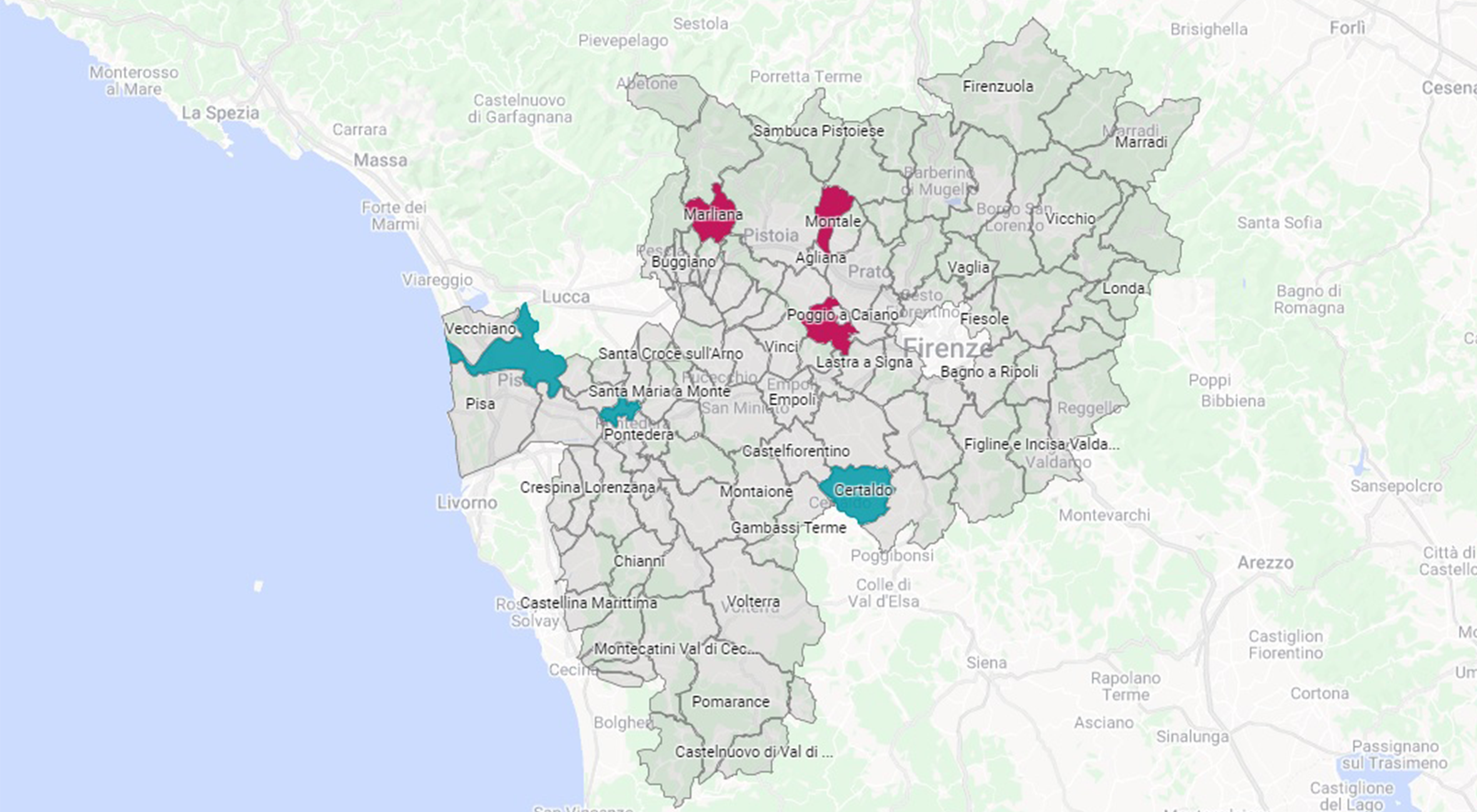
MAGOH is one of the winner projects on the call named “100 assegni per la Cultura” promoted by Regione Toscana. The aim of the project is to create a platform of archaeological data managing about the Province of Pisa and the urban area of Firenze. MAGOH will allow the data access and the optimisation of the cycle of the archaeological data, improving research, protection and enhancement actions.
From Vitruvio to ArchaeoBIM. BIM reconstruction of the archaeological context of Massaciuccoli, Massarosa - LU (2021-2024)
In the debate on the search for new archaeological methodologies, the use of BIM (Building Information Modelling) has begun to develop over the last decade. This technique, derived from disciplines such as architecture and civil engineering, involves the creation of 3D models of architectural objects correlated with a series of databases, allowing the simultaneous management of a large amount of heterogeneous data.
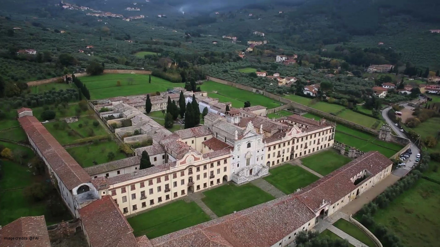
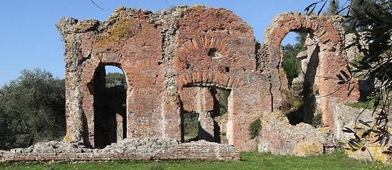
Garden archaeology at Certosa di Calci (2017- on going)
The University of Pisa, through a large consortium of its departments, has activated a large program of conservation and enhancement of the Certosa di Calci complex and its museum poles.
The MAPPA Laboratory will focus on the Archaeological Impact Assessment (VIArch) and on the collection and management of all the archaeological data of the territory of the Municipality of Calci.
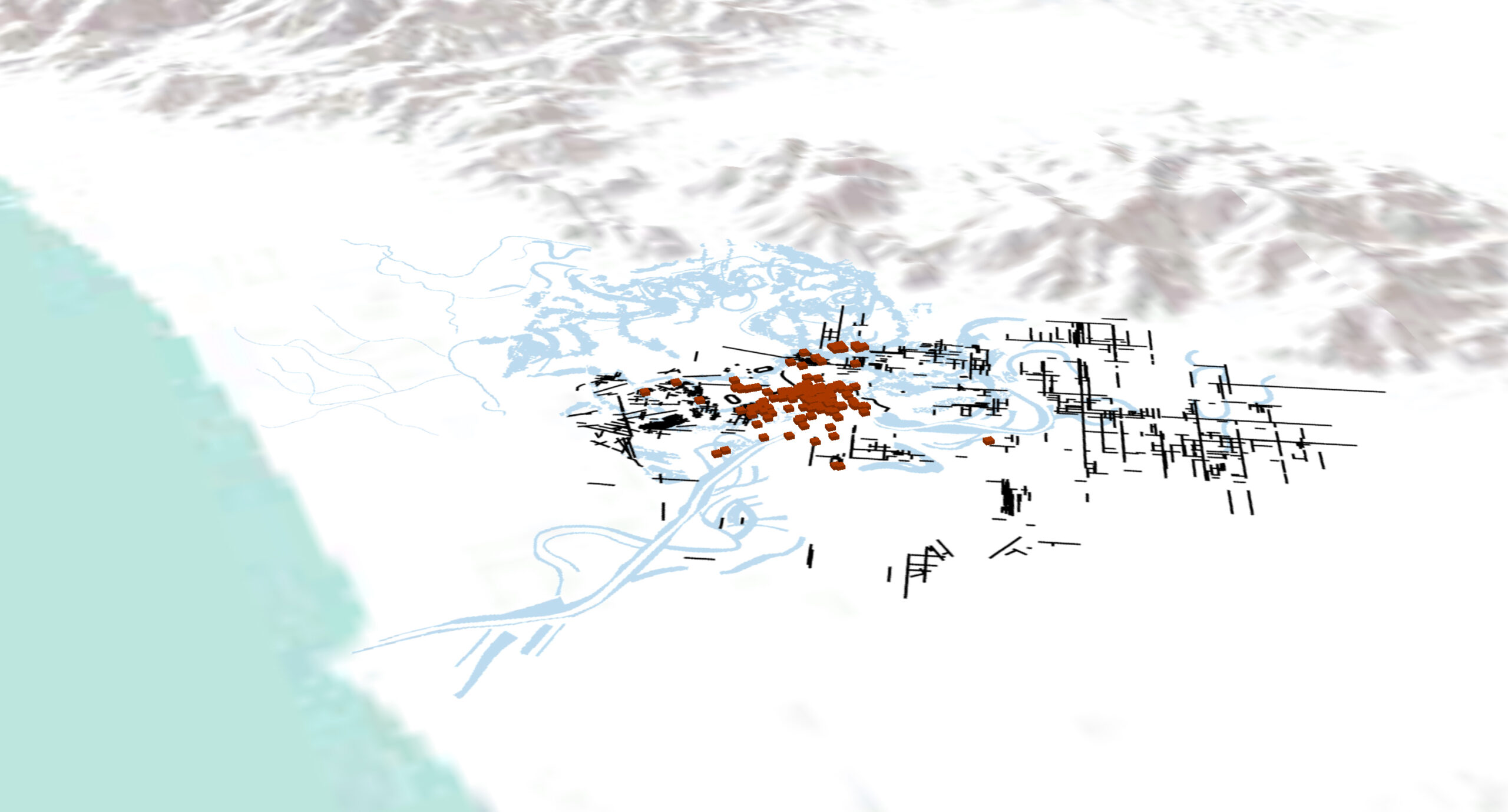
The Ager Pisanus between Romanization and Late Antiquity (III century BC-VI AD): continuity, discontinuity and transformation (2018-2022)
The research aims at the study of the city and the territory of Pisa between the Hellenistic age, the Roman age and the late antiquity, for an analysis of the settlement dynamics in a long-term perspective.
ArchAIDE (ARCHaeological Automatic Interpretation and Documentation of cEramics, 2016-2019)
The MAPPA lab is coordinator of the ArchAIDE project, funded by H2020-RIA programme.
ArchAIDE aims to create a tool for the automatic recognition of ceramics through the use of deep learning. Starting from a simple photograph, the ArchAIDE App will provide the digital classification of each fragment correlating it with the information of the ceramic catalogs for the first time available online.
NLP (Natural Language Processing) (2018- on going)
The techniques allowing the extraction of such information from documents are part of Natural Language Processing (NLP): these are algorithms that extract, structure and analyze information from textual sources.
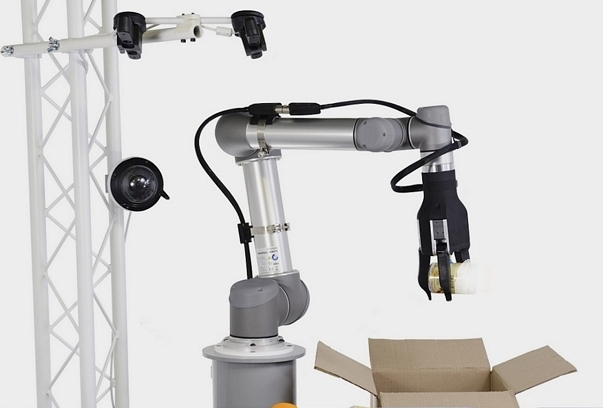
AI controlled robotic arm for classification and selection of archaeological ceramic fragments
In recent years, increasing attention has been paid to the use of methodologies related to ICT also in the humanistic field, in particular with regard to archeology which is considered since a long time a science on the border between humanities and technical-scientific disciplines. The aim of this project is to create a robotic arm that is able to autonomously select the fragments based on the information received from ArchAIDE.

Memories of things, places and life.
The landscape transformation after the Second World War is a natural theme for those who live in mountain areas. The depopulation of villages and high-altitude sites and the abandonment of crops and woods is still partially legible today in the tangible and intangible memories with which local communities are confronted daily.
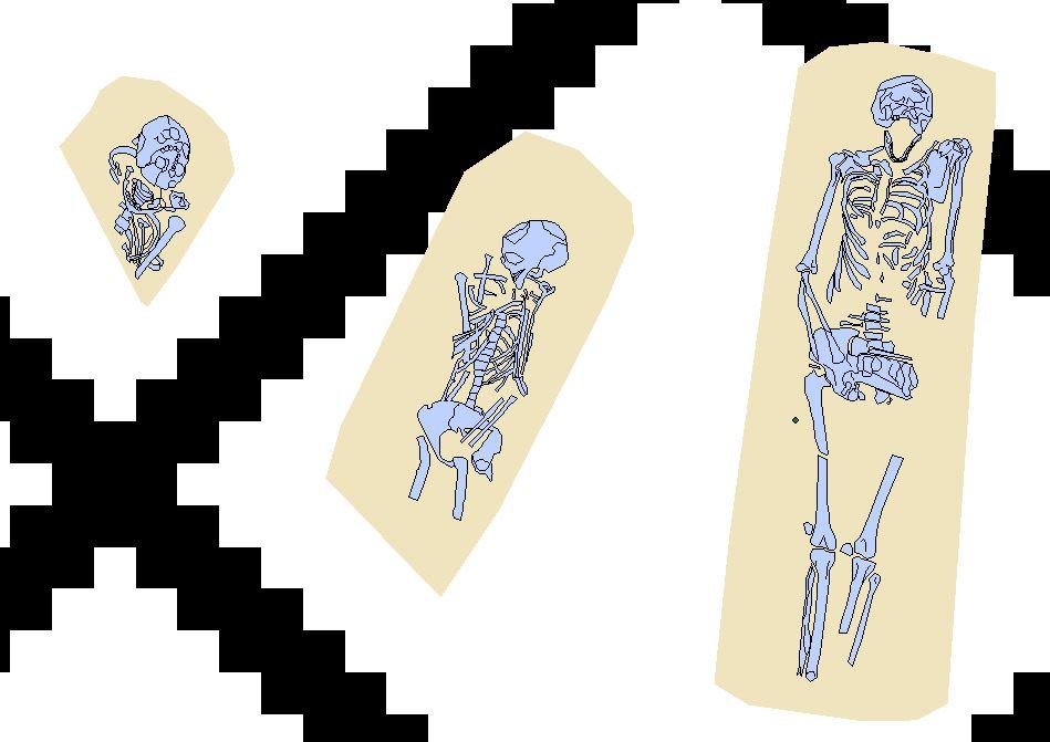
The urban necropolis of Pisa between late antiquity and the early Middle Ages (2019-2020)
The work is part of the University Research Project (PRA) “Funerary landscapes between ritual and society. New approaches to the study of necropolis in the ancient world “, coordinated by Anna Anguissola. The biennial project is aimed at studying necropolises in different contexts, both spatial and chronological.
MAPPAGIS
The MAPPA web-GIS is the digital mapping instrument used for the free publication of archaeological, geological and geomorphological data on the web. The MAPPAGIS was created in the MAPPA project and records all the archaeological interventions carried out in Pisa from 1562 to today. Through appropriate implementations, the web-GIS provides access to topics of scientific and public interest regarding archaeological mapping, archaeological potential mapping and geomorphological mapping.
The MAPPA web-GIS is a dynamic and up-to-date tool that can be freely consulted and that enables real-time queries of data and relevant analysis.
MOD
MOD (MAPPA Open Data) is the first italian digital archaeological archive developed to preserve
and disseminate the archaeographic documentation (Datasets) and grey literature (Reports) produced during archaeological surveys.
The MOD protects those who have produced the documentation in all its forms through the application of a DOI to each Dataset and / or Report and the use of the CC BY-SA 3.0 license, in order to simultaneously allow the correct circulation of data and the protection of intellectual paternity.
MAPPA Project (Methodology Applied Archaeological Potential Predictivity, 2011-2013)
The MAPPA project, conducted by a consortium of Departments of the University of Pisa (Civilization and Forms of Knowledge, Earth Sciences, Mathematics), was aimed at the creation of a Charter of archaeological potential of the city of Pisa developed through a predictive algorithm. Through the digitization, management and georeferencing of all the archaeological data of Pisa, during the two years of research, an archaeological WebGIS, an OpenData digital archive (MOD) and paleogeographic maps were created.